
Kurdistan means the Kurds' land and the Kurdish nation's settlement. A nation with its own history, geography, culture, flag, and language.
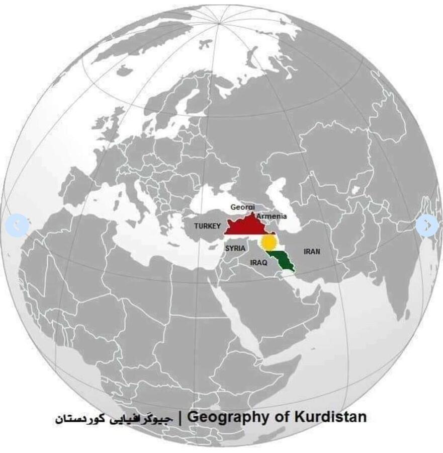
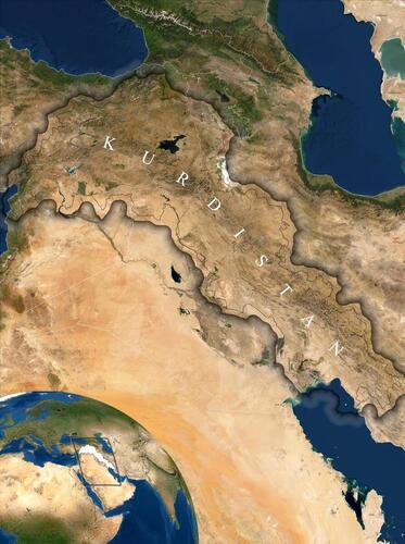
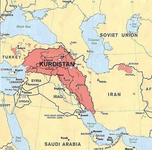
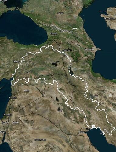
The border of the Great Kurdistan in general
The Great Kurdistan is located in southwestern Asia. It is bordered by Azerbaijan and Armenia to the northeast, Turkey to the north and west, Iran to the east and southeast, and Iraq and Syria to the south and southwest.
1. Mir Sharafkhan Badlisi (1598 AD) believes that the border of Great Kurdistan starts from the Persian/Arabian Gulf and extends north to the provinces of Malatya and Marash, and to the north of this line, the provinces of Kars, Azerbaijan, and small and large Armenia and to the south of this line are Arabic Iraq, the provinces of Mosul and Diyarbakir.
2. The famous orientalist Edmonds believes that the border of Great Kurdistan extends in a straight line from Yerevan to Erzurum and Marash and to Aleppo in an arc to the west; it then flows eastwards along the foothills to the Tigris River, and a little north of the Hamrin Mountains to the Iraqi-Iranian border near Mandali. However, in the eastern direction, the Kurdistan border extends from Yerevan to the southeast and is believed to include all the following cities: Mako, Khoy, Urmia, Mahabad, Saqqez, Sna, Kermashan, and Ilam.
3- In his doctoral thesis in 1965, Dr. Abdul Rahman Qassemlu stated: The Kurdistan border starts in a straight line in the northeast of the peak of Ararat, heads south to the southern part of the Zagros Mountains and descends straight; from there we draw a straight line northwest to Mosul in Iraq, and from there a straight line west from Mosul to the Turkish part of Alexandria, and from there a line northeast to Erzurum in Turkey; then from Erzurum a line runs eastwards to the summit of Ararat.
4. The famous Turkish traveler Awliya Chalabi says that Kurdistan consists of the provinces of Erzurum, Van, Hakkari, Diyarbakir, Jazira, Amedi, Mosul, Sharazur, and Ardalan and the path is seventeen days.
Area of Great Kurdistan
The total area of Great Kurdistan is 409,650 square kilometers.
1. The length of Great Kurdistan from north to south is between 1000 and 1300 kilometers.
2. Its width ranges from 750 km from east to west to 250 km in some parts of the southeast.
Area of Kurdistan Parts
The total area of North part of Kurdistan is 194,400 km2
The total area of East part of Kurdistan is 124.950 km2
The total area of the Southern part of Kurdistan is 72,000 km2
The total area of the western part of Kurdistan is 18,300 km2
Percentage of Kurdistan parts compared to Great Kurdistan
1- North part of Kurdistan (Turkey) 47.50%
2- East part of Kurdistan (Iran) 30.50%
3- South part of Kurdistan (Iraq) 17.50%
4- West part of Kurdistan (Syria) 4.50%
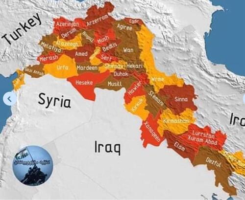
Cities of Great Kurdistan
Great Kurdistan has about 100 large cities, including:
In the North part of Kurdistan:
Amed, Agri, Jolamerg, Mamaki, Samsur, Erzurum, Batman, Badlis, Van, Mardin, Alazik, Bingol, Orfa, Shrnakh, Mush, Kars, Hakari, Sert, Adiyaman, Erzingan, Rha, Chewlik, Antakya, Marash, Sivas, Malatya, Delok, Kharpet, Erdekhan, and ...
In the East part of Kurdistan:
Kermashan, Urmia, Sna, Khormawa, Ilam, Bokan, Saqqez, Mahabad, Bijar, Khoy, Salmas, Mako, Mariwan, Qurwa, Sarpeli Zahaw, Sahna, Kudasht, Pol Dukhtar, Delfan, Karand, Shabad, Qasri Shirin, Pawa, Jwanro, Rwansar, Kamyaran, Sardasht, Shino, Diwandara, Piranshar, Mianduaw, Naghda, Tikab, Sayin Qala, Harsin, Gelan, Dalaho, Badra, Awdanan, Deluran, Mehran, Sirwan, Malekshay, and ...
In the Southern part of Kurdistan:
Hawler (Erbil), Sulaimani, Kirkuk, Duhok, Halabja, Shangal (Sinjar), Soran, Zakho, Rwandz, Pirmam, Shaqlawa, Koya, Ranya, Qaladze, Arbat, Sayd Sadiq, Sirwan, Kalar, Kufri, Darbandikhan, Dukan, Taqtaq, Chamchamal, Makhmur, Akre, Khanaqin, Badra, Mandali, and ...
In West part of Kurdistan:
Qamishlo, Afrin, Serekani, Kobane, Amude, Gre Spi, and ...
Partition of Great Kurdistan
The territory of Great Kurdistan is divided into several countries according to the following treaties and the borders between these parts of Kurdistan are defined.
1. The Treaty of Amasia in 1555
2- Treaty of Zahaw in 1639
3- Battle of Chalderan in 1514
4. Treaty of Erzurum I in 1823
5. Treaty of Erzurum II in 1847
6. Sykes-Picot Treaty of 1916 between France and Britain.
Finally, the territory of Great Kurdistan was divided into four countries: Iran, Turkey, Iraq, and Syria. Because of this division of Kurdistan, determining the borders of Great Kurdistan is a sensitive political issue.
The most important climate regions of Great Kurdistan
1. Hot dry climate region.
2. Dry and hot desert climate region.
3. Tropical semi-desert climate region.
4. Cold mountainous climate region.
5. Mediterranean climate region.
Lakes of Great Kurdistan
Van, Urmia, Alman, Zrebar, Hapar, Man Gsht, Barm Shur, Mur Zard, Tanka Sur.
Great Kurdistan connects the three Arabian, Eurasian, and Iranian plateaus and is the main area connecting these plates.
Great Kurdistan occupies an important geographical area in Asia and the Middle East. This has led to increased natural and political importance and constant attention to different regions of Great Kurdistan.


