South Part of Kurdistan
Generally, when it comes to the geography of that part of Kurdistan that is located in Iraq it is referred to as the South part of Kurdistan, while it has, in fact, a central location since it is the point where the North, East, and West parts of Kurdistan are contacting. This part of Kurdistan is very rich in natural and underground resources. The highest peak of this region is "Hasarust" which is located on the Halgurd mountain chains on the border between the East and South parts of Kurdistan. The summit of this mountain is 3727 meters above sea level. On the other hand, a lower and drier chain of mountains called Jabal Al-Hamrin forms the natural boundary between Kurdish and Arabic regions.
There are various patterns of climate in the South part of Kurdistan. In the northern and southern parts of this region, the average temperature and rainfall are very different from each other. The most important source of rainfall in the region is the western rainy air mass which brings the Mediterranean Sea moisture in the form of sufficient rainfall in the Autumn, Winter, and Spring seasons.
Winter is the rainiest season in Kurdistan and the driest season is summer. The average rainfall in the South part of Kurdistan is 600 mm.
Area of the South part of Kurdistan
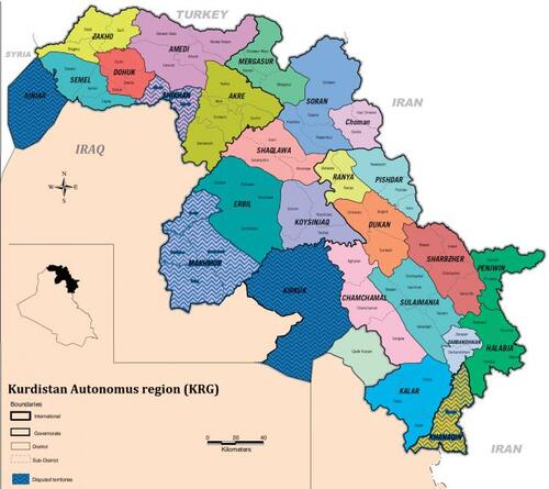
After the changes made in the March 11, 1970 agreement on the borders of some Iraqi divisional units, Iraq was divided into 16 provinces, four of which were completely in Kurdistan land: Hawler, Suleimani, Duhok, and Kirkuk.
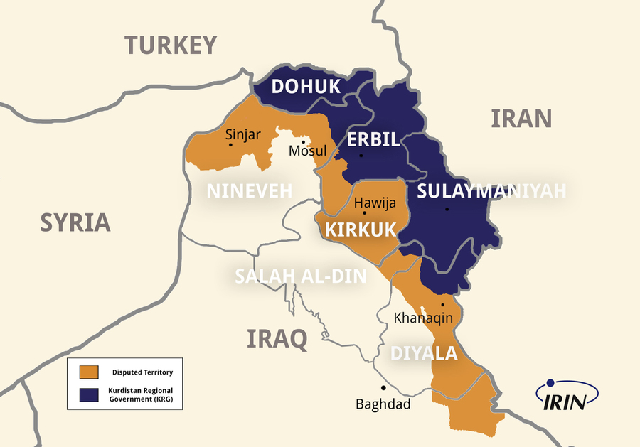
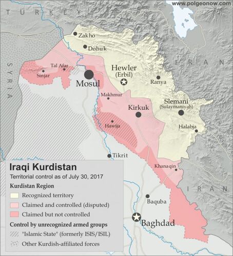
Considering that the ruling governments in Iraq until the fall of the Ba'ath regime restricted the Kurdistan areas of Iraq to only three provinces: Suleimani, Hawler (Erbil), and Duhok, according to the Unilateral Agreement signed in 1974, the framework of Iraqi Kurdistan under Iraq's control got limited to these three provinces, thus, it is difficult to estimate the area of the South part of Kurdistan accurately. We will discuss this matter from different perspectives in this article.
The Encyclopedia of Islam, one of the most important sources of Orientalism, defines South part of Kurdistan as follows: in Iraq, the Kurdish cities include Duhok, Zakho, Mizuri, Jeez, Amedi, Akre, Shingal (Sinjar), Kirkuk, Hawler, Sulemani, Diyala, Khanaqin, and Mandali.
Regarding the southern border of Kurdistan in the South part of Kurdistan Edmonds said: "The southern border of Kurdistan, along the mountains, was drawn to the river bank of Tigris River and then it was drawn in the direction of the river to the Hamrin mountains and from this point it stretches to the border zero point of Iraq-Iran border near Mandali.
Minorsky believes that the southern border of Kurdistan is drawn to the north of Mesopotamia plains, while "M. Lekhovten" assumes that Kurds live in the mountainous areas and Iraqi people live in the plains of both sides of Tigris and Euphrates Rivers.
"W. R Heye" pointed out: "In general, all the lands on the east of Tigris, the north of Mandali borders, and the area where Little Zab River is covering belongs to the Kurdistan land. This is why the two main parts of the south of Little Zab are Kirkuk and Suleimani.
The area of the South part of Kurdistan is about 85000 square kilometers and it includes 37 cities that are located in these provinces:
1. Duhok Province: Duhok, Amedi, Zakho, Semel.
2. Hawler Province: Hawler, Makhmour, Koya, Rwandiz, Shaqlawa, Choman.
3. Suleimani Province: Suleimani, Penjwen, Sharbajer, Pishdar, Raniya, Darbandikhan, Chamchamal, Kalar.
4. Halabja Province.
5. Kirkuk Province: Kirkuk, Hawijah, Doubz.
6. Salahaddin Province: In this Province, Touzkhourmatou is a part of Kurdistan.
7. Mosul Province: Mosul, Hamdaniyeh, Tlkif, Shangal, Shekhan, Akre, Tala'afar.
8. Diyalah Province: Khanaqin, Mandali, Sharaban, Kifrie.
9. Wast Province: In this Province, Badra city belongs to Kurdistan.
The Parliament of South part of Kurdistan, considers the area of Kurdistan region 78736 square kilometers which covers about 18 percent of Iraq's total area.