
Kurdshop – Amed, Amedan, or Diyarbakir is one of the largest cities and provinces in North Kurdistan. Amed is also one of the largest cities in Turkey and is considered the real capital of Kurdistan among the Kurds. Today, Amed is famous nationally and internationally for its castles, walls of Diyarbakir, and watermelons.
Diyarbakir was known as Amid and Amida during the Aramaic period of 1300 BC. Later it was known as Amed, Amederash, Diyarebakir, Diyarbakir, and finally in 1928 by the Turkish state as Diyarbakir.
Diyarbakir covers an area of 15354 square kilometers and according to some sources, the meaning of Amed and Amida comes from Amedana. According to other opinions, the name of the city Diyarbakir comes from a Syriac word meaning "Dayrul Bikr" meaning "Holy Church", and this church is still important in the great city of Amed.
Diyarbakir is located between 37° 30' and 38° 43' North and 40° 37 and 41° 20' East. It is surrounded by the provinces of Ilih and Sert in the east of Diyarbakir, Merdin in the south, Riha and Samsur in the southwest, and El-Aziz in the north.
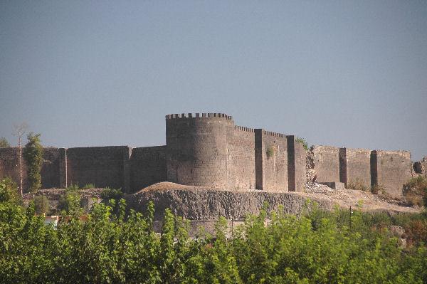
Amed covers an area of 15354 square kilometers and has many historical sites. First, Beden and Sur, or Diyarbakir Castle, and its towers are very famous and included in the UNESCO World Heritage List.
There are 17 other cities in Amed province and the city’s four districts. There are also 32 towns and 841 villages. Amed is a major city in Turkey and the four districts of the city are New City, Payas, Rezik, and Sur.
Other names of cities and towns in Diyarbakir include Bismil, Cermug, Cinar, Ergani, Hene, Hezro, Karas, Pasur or Qulp, Piran, Lice, Farqin, Cingus, Gel or Egil.
In Diyarbakir, Mount Karajdak (1919 m), Piraceman (2010 m), Mihrab (2100 m), Adam (2100 m), Lis (2200 m), Suplis (2280 m), Koz (2283 m),
Qardilak (2350 m), Barbehev (2593 m), and Andok (2830 m) are the highest mountains.
The Tigris River, on the other hand, is the largest in the region. The Ambar River in Qulp and Ferqin, the Media in Cermug, and the Kalkhana in Ergani are other rivers in the region. There is no natural waterfall in Diyarbakir; there are dammed lakes such as Devegecdi, Qaraqeye, Qurtkiye, Ortaviran Goksu, Kirlqizi, and Gozegol, and the Sarumi River in Pasur and the Sekiran River in Lice.
Diyarbakir's underground resources include iron, copper, zinc, manganese, asbestos, gunpowder, phosphate, brick and tile materials. Veins of oil have been discovered in recent years, particularly in Farqin and Bismil, but they have not yet been exploited.


