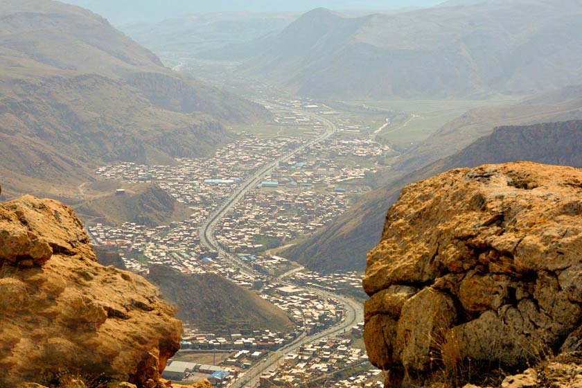
Maku is the northernmost city in East Kurdistan, located in the north of Urmia province, on the border between North and East Kurdistan. It is bordered by the Karasu River and North Kurdistan in the north, the Aras River, Azerbaijan, and Poldasht in the east, North Kurdistan in the west, Showt in the southeast, and Chaldoran in the southwest.
Maku is located between the two Mountains of Qaya in the north and Sabaddaghi in the south. The Zangmar River, which originates from the mountains on the border between North and East Kurdistan, flows through the city and then flows into the Aras River in Poldasht. On this river, 12 kilometers south of Maku, a dam called Maku Dam has been built near the village "Barun", also known as Barun Dam.
Maku is located at 44 degrees 20 minutes east longitude and 39 degrees 18 minutes north latitude, and its height is 1634 meters above sea level. According to the 2016 census, the population of Maku was 46,581, mostly Kurds.
Maku has 130 villages, 102 of which are Kurdish and 19 of which are Azeri Turks. The population of nine villages is a mixture of Kurds and Azeri Turks.
Kurdish villages include 102 villages:
Adakhan
Aq Gul
Ikhlkhan
Ilan Qara Khwaru
Ilan Qara Saru
Inje Haji Mohammed
Inje Nuralla
Barakhodik
Biri
Belajak
Pancherly
Tatar
Tazekand, Maku
Tazekand Adakhan
Tazhdu
Takhtaduz
Tarakma
Tikmakurd
Tilmakhan Khwaru
Tilmakhan Saru
Jaganluy Kurd
Jol
Haju
Haji Hassan, Maku
Hasun Bchuk
Hasar, Maku
Hasushki
Hasulezgi
Hasoshiri
Khzrqshlaq
Kharman, Maku
Khulkhula
Darik
Darwesh Kandi
Dewabatan
Dimghshlaq
Zalka Khwaru
Zalka Saru
Zorawa
Sarnj
Saeedawa
Surk
Shaawa
Shatr
Shakefte Khale
Shuraq Gul
Shurk
Shekhali Jan
Abdullah Kandi
Ajami
Aluhaji
Ali Farash
Ali Qando
Aliaway Rnd
Isa khan
Isa Kandi
Qadir Qumu
Qzl Harqi Khwaru
Qzl Harqi Saru
Qzldaghi Kurd
Qishlaq Bahlul
Qishlaq Duman
Qishlaq Na'mu
Qarablagh, Maku
Qaraquyun
Qalachugh, Maku
Quchali
Quri Shkak
Qush
Qum Qishlaq
Qoribulagh
Karwanqran
Karezi Khwaru
Karezi Saru
Karezi Mayil Kandi
Kuliki Taza
Kuliki Kon
Gamiz
Girkk, Maku
Gadali
Gul Murs
Gulali
Gome Maro
Mayil Kandi
Mohammadawa
Mustafa Qalasi
Mahmud Aghul
Makhand
Mala Hasan
Malham
Mahdi Bulagh
Mus
Mulik
Mirza Khalil
Mirza Dolmez
Milan, Maku
Horo
Wali Kandi
Yarm Qayay Khwaru
Yarm Qayay Saru
Yarm Qayay Nawarast
Yaqubali Kandi
The Azeri villages include 19 villages:
Aghbulaghi Chamanlu
Barun
Bijan
Turkan
Tikmay Ajam
Janaziz
Jaganluy Ajam
Chamanlu
Hassuni Gawra
Danaluy Bchuk
Danaluy Gawra
Dargaqulu
Dibak
Qzaldaghi Ajam
Qarabulagh, Maku
Qaraghaj
Qalajuq, Maku
Mohammad Kandi
Handawar
The Kurdish-Azeri mixed villages include 9 villages:
Olenner
Bakhchechugh
Bashkand
Rind
Sanger, Maku
Qaratapa, Maku
Kshmish Tapa
Kose, Maku
Gajut
The name of Maku:
The people of this area became Zoroastrians in the first century BC; therefore, they named the city "Mugh Ko" or "Magh Ko", which means the place of Zoroastrian religious scholars. Over time, the name became Maku from "Magh Ko".
Maku means "pasture" in Armenian and is said to be named after the large pastures in the area.
Some other people believe that the Medes settled in this area during the reign of Astyages, which is why they named the area "Mad Kew" meaning the mountain of the Medes, but later the name changed to "Maku".
Maku Economy:
Because the city is located on the border between Turkey and Iran, it has become a business city, and some people are engaged in gardening, agriculture, and livestock.
In 2011, the Iranian government declared the Maku Free Trade Zone, the second-largest free trade zone in the world and the largest free trade zone in Iran. This changed the working life of the city's people and its surroundings completely, and their job opportunities changed from agriculture and livestock to business and trade work.


